
Cycle Infrastructure
Cycle Network
Bedford Borough's Cycle Network (BCN) consists of 27 strategic radial routes focussed on the town centre snd two orbital routes - The Avenue (BCR A) and Bedford Green Wheel (BGW).
The network is basically a dual network with routes varying in type and purpose from
• quieter more safer routes using paths and mainly 20mph residential roads for new/less confident cyclists and
There is currently 136km of urban cycle network based on CCNB's Bedford and Kempston Cycle Map made up of 71km off-road, 61km quiet roads and 4km on-road cycle lanes. In addition there are 14km of unsurfaced tracks/bridleways and 6km of one way bus lanes.
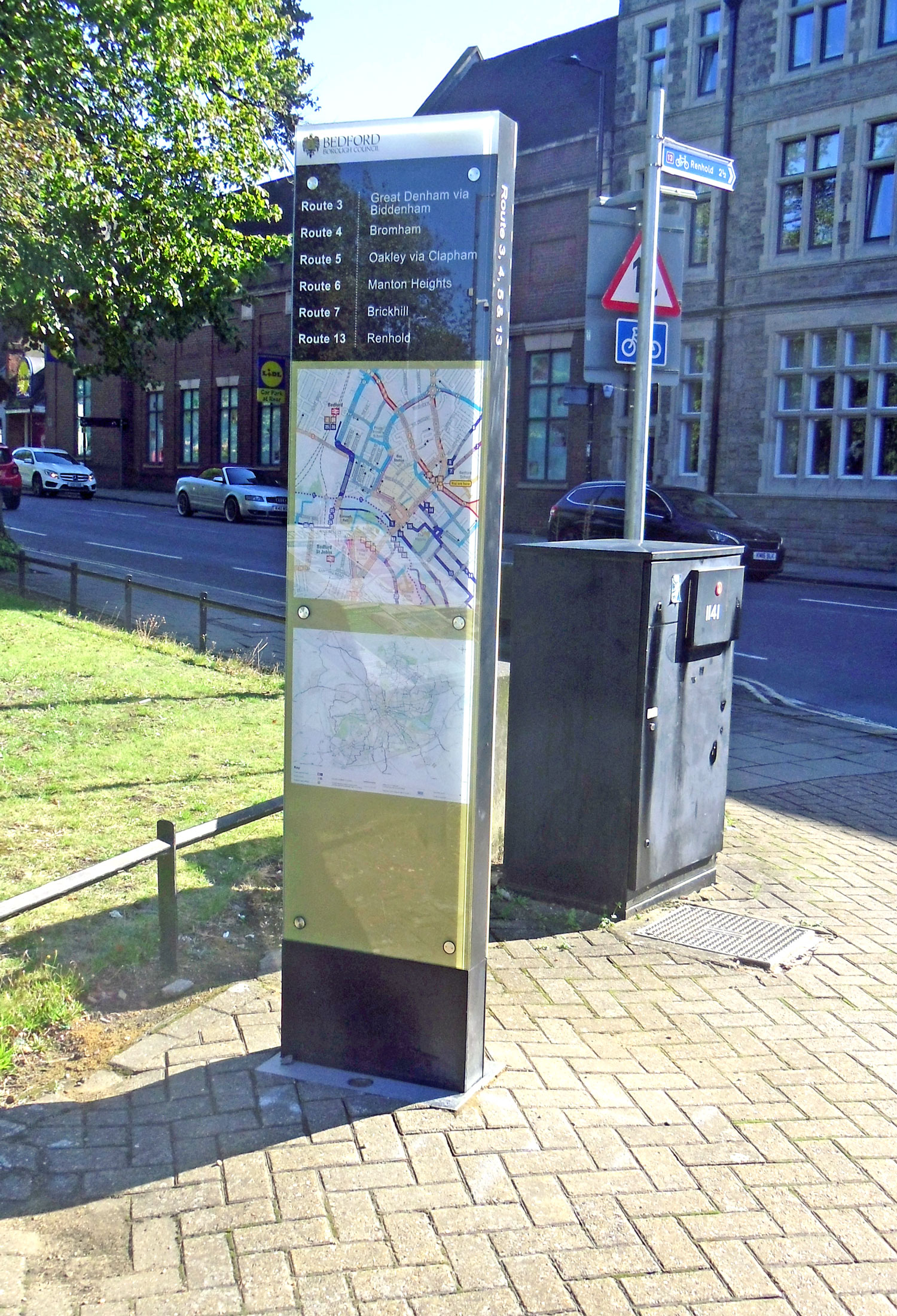
During 2021 all of Bedford's cycle network has been signposted using £380,000 of the £1m grant awarded to Bedford from the government’s town deal accelerator fund. Each junction has a finger post showing the the route number. Only the beginning and end of the routes give an indication of their destination although in some areas there are still location signs installed a number of years ago.
In the revamped High Street near Mill Street and also at the junction with St Peter's Green and The Embankment and some other locations information boards have been erected with a map of the town centre as seen in other parts of the central area but also showing the number of each cycle route starting from the town centre.
The following short video describing the current network has been published by CCNB.
Short videos on each route are in progress and can be seen here.
Signalled Crossings
63 Toucan crossings (including 2 Pegasus) have been installed over the last two decades in the urban area to improve cyclists’ safety in crossing busy main roads. This is in addition to the many underpasses and central reservations, 4 Parallel Crossings* (Cycle Zebras) and also 33 Puffin/Pelican and 8 Zebra crossings which cyclists can use to safely walk across.
*The remodelled Union Street roundabout (October 2014) has the first 4 Parallel Crossings.
Further signalled crossings are likely to be provided over the next few years to improve the safety of cyclists and pedestrians. Crossing Status.
Advanced Stop Lines
There are 13 sets installed at junctions.
Cycle Parking Spaces
There are more than 3000 cycle parking spaces, mostly based on the 'Sheffield' type of stand; 547 around the town centre, 630 at the railway station (including 24 at the Borough's adjacent Ashburnham Road car park) and more than 3000 other public, school, college and private spaces.
Other Infrastructure
Within Bedford Borough outside of the urban area there are also a total of 350km of Bridleways and 34km of Public Byways (BOATS) which can be used by cyclists.
Back to top
Cycle/Pedestrian Bridges
A number of new cycle/pedestrian bridges have been or are expected to be built in the future across the River Great Ouse.
'Britannia' bridge to link the Britannia site development (Kempston Road) with the north riverside route (Route 51) was opened on 26 June 2014.
A bridge to link Great Denham with Hillgrounds Road Kempston originally proposed as part of the Great Denham development was abandoned in 2018 due to concerns of the Environmental Agency.
Kempston Mill bridge was expected to be made cycle and disability compliant when funds were available. Unfortunately the bridge deteriorated during 2016/17 and a direct replacement made of steel instead of wood was installed during August 2017. The steps on each side are still of wood. A promise by the Borough Council to replace these by disability compliant ramps in mid 2018 subject to Environmental Agency approval has not materialised to date.
The original Riverside Square development which was to have included a bridge linking Kingsway (and the south riverside route) with the town centre (Horne Lane) was cancelled due to the economic downturn but has now been replaced by a similar four metre wide bridge as part of the Riverside North development which commenced in 2015. The bridge was lifted into place on 1 July 2016 and opened on 2 June 2017.
Clapham Ford will eventually have a bridge as part of the outer Green Wheel between Clapham and Bromham. A proposed bridge at this point was put forward as a potential scheme for Sustrans Connect 2 project in 2007 which had received £50 million from the Big Lottery fund's Living Landmarks; The People's Millions competition. Unfortunately it was not in the final list of 79 schemes. The only successful one in the vicinity of Bedford was the St Neots bridge between Eynesbury and Eaton Socon which was completed in September 2011.
A 'Meccano' type spiral bridge across the Marston Vale railway line next to the riverside cycle route was constructed in 2013 to replace an old footbridge which had to be dismantled in 2011 to allow overhead cables to be installed on this section of line to accommodate new sidings for 12 carriage length trains as part of the Bedford to Brighton route upgrade.
A wooden bridge, similar to the one across the Ridgmont bypass, will be constructed across the A4280/A6 link road for pedestrians and cyclists to access the new country park to be designed along the river as part of the North of Bromham Road development.
Roundabouts
In 2013 a grant was obtained by Bedford Borough Council from the Department for Transport's Cycle Safety Fund to improve the Union Street roundabout for cyclists (and pedestrians). The approved design resulted in some negative (and incorrect) publicity and the start of implementation delayed until the 2014 summer holiday period. The work was completed in October 2014 although some snagging issues were not remedied until March 2015.
CCNB's earlier response to critics can be seen here.
Back to top
Major Developments
There is generally several years lead time between a developments inception and seeing concrete evidence of it on the ground. CCNB has been involved in many development briefs and consultations and continuously monitors all planning applications and policy decisions to ensure that provision for cyclists is provided or, in the case of small developments, to ensure that a contribution is made for improvements in the immediate area.
Great Denham
Kempston West
The Wixams
Fields Road Wootton
New Cardington
Norse Road
Norse Road (2)
North Biddenham (North of Bromham Road)
North of Brickhill
Town Centre Area
Castle Quay
Riverside North
Riverside Square
Town Centre West
Britannia Site
Station Quarter
Great Denham
The development originally called Biddenham Loop is nearing completion with a number of cycle routes built throughout the development including the new route for National Cycle Network Route 51 between the development and the new riverside country park.
The riverside path from The Slipe to the start of the Great Denham development, part of the future Route 51, was upgraded during 2013.
Back to top
Kempston West
This development is nearing completion and contains part of the new route for National Cycle Network Route 51 as well as local cycle routes.
Back to top
The Wixams
The Wixams development will eventually house 10,000-15,000 residents. The first of the four villages, Village One, has now been completed and has an off-road cycle track alongside the old A6 linking the outskirts of Wilstead and Elstow via north and south cycle/pedestrian underpasses of the new A6 bypass.
Highways England (originally the Highways Agency) announced in March 2015 that as part of the Government's Cycle Proofing agenda a project had been approved for the Southern Bypass A421/A6 junction to be signalled together with a new cycle track from the northern underpass alongside the A6 and across the junction to join the existing cycle track through the Progress Business Park to give a more direct route via Ampthill Road to the Interchange Park, Hospital and Bedford town centre. The project was expected to be completed during the 2016/17 financial year but has been paused due to a claimed 'poor value for money'. This has been contested by both the Borough Council and CCNB and a further review is underway by Highways England but a report due by March 2018 has still not materialised (December 2019).
Major road infrastructure for the rest of the development with cycle tracks initially along one side only, will be put in place over the next few years to join up with the proposed new Wixams railway station. This was due to open at the end of 2015 but due to funding issues is now not expected to open for a few years.
Back to top
Fields Road Wootton
The Fields Road development is well under way. The easterly section in the future will contain, parallel to the A421, a section of the new route for National Cycle Network Route 51 as well as sausage shaped ponds for the future Bedford to Milton Keynes canal. In early 2014 a new roundabout was constructed along Fields Road which includes a short section of cycle track and bridleway together with a Pegasus crossing of the road to the east of the roundabout.
Back to top
New Cardington
The development of the old RAF Cardington site adjacent to Shortstown started in 2008 with the semi-circular diversion of the A600, now called Carmichael Drive. More than 5,000 houses are being built in a number of phases linked by a comprehensive network of cycle routes.
Back to top
Norse Road
The development on the west end of Norse Road was completed in 2014. The off-road dual use track between the Hookhams Lane/Church Lane roundabout and the cemetery entrance was constructed in 2007 as part of the development.
Back to top
Norse Road (2)
A further development (Orbit) on Norse Road between the above and the cemetery was completed in 2017. A new roundabout on Norse Road was built in 2012 to service the development necessitating the existing off-road track to be diverted around it. This track now continues to Asgard Drive and then goes over and behind Renhold Brook to join the Pegasus crossing on the A4280 St Neots Road, just east of the roundabout.
As part of the conditions for the development a toucan crossing on Norse Road, midway between the two developments, was opened in early 2014 to provide a link, via a short dual use path to Glenavon Road, from the estate to the Church Lane Shopping Centre and Putnoe Primary School. The bridleway, BW24, was upgraded in 2015 from Salph End to the cemetery with a link to Renhold Lower School.
Back to top
North Biddenham (North of Bromham Road)
The start of this development was delayed by the economic downturn but has now started (January 2016). The development when completed will contain an extensive cycle network.
In the meantime the missing part of the Western Bypass to link Bromham Road (A4280) with Clapham Road (A6) started in October 2014 was opened on 25 April 2016. The link road, named The Great Ouse Way, has an off-road cycle track on the south side between Bromham Road and Clapham Road. At the Bromham Road end an underpass has been constructed to allow the existing Bromham to Bedford off-road cycle track to safely cross the new link road. The completion of the road will enable the possible future closure of the High Street to unnecessary traffic and allow the creation of a two way north/south cycle route through the town. To date (December 2019) improvements are outstanding.
Back to top
North of Brickhill
The housing development known as Woodlands Park has now been completed together with an adjacent Country Park. An off-road cycle track was provided from Tyne Crescent along the spine road (Ashmead Road) to and through the site to Westrope Way
As part of the developer's Section 106 agreement the bridleway from Westrope Way to Anjulita Court known as 'The Ride' has been widened and surfaced and will become an attractive entrance to the Country Park. A dual use track has also been provided from the edge of Clapham Park Wood, crossing Ashmead Road and then going between the development and Browney Walk to Westrope Way before continuing eastwards to the end of the development site behind Hamble Road.
Bedford Borough Rights of Way submitted a bid in June 2012 to the Wren Land Fill Tax Fund for a grant to enable the track to be extended through Freeman's Common along the route of the bridleway to Kimbolton Road and then south behind Douglas Road to the Pegasus crossing on Kimbolton Road opposite Mowsbury Park. The grant was not approved and other funding sources are still being explored. In the meantime the narrow bridleway can only be cycled safely when the ground is dry.
Back to top
Castle Quay
The development is complete. Public cycle stands (8 'Sheffield' stands) were provided off Castle Lane next to the entrance to The Higgins (known previously as Bedford Museum). In November 2013 the town's last remaining 'Not Fit for Purpose' butterfly stands near Ram Yard were replaced by 10 'Sheffield' stands.
Back to top
Riverside North
This new development on the Riverside Square/Town Hall site received planning approval in March 2013 and work construction work commenced in 2015. The site opened to the public in June 2017 and has 102 additional public cycle stand facilities and a new cycle/pedestrian bridge (see under Bridges above) across the River Great Ouse.
Riverside Square
This development including a new pedestrian/cycle bridge across the River Great Ouse was cancelled in 2010 due to the economic situation (see Riverside North above).
Back to top
Town Centre West
This development was finally cancelled in 2013 due to the economic climate caused by the banking crisis of 2008.
Back to top
Britannia Site
Three phases of the development have been completed and a further phases are under construction (2019). As part of the development a new pedestrian/cycle bridge (The 'Britannia' Bridge) was opened in June 2014 from the development to the north side cycle track (National Cycle Network Route 51) along the River Great Ouse. From the development side of the bridge there is a link to the Kempston Road off-road cycle route.
Back to top
Station Quarter
The major development on this site was postponed in 2010 due to the economic situation. The southern section (the old 'Focus' site) has been turned into a temporary car park with 24 covered cycle spaces (12 'Sheffield' type stands) at the station end.