
20mph Speed Limits/Zones
Lowering the speed of traffic in residential areas has become one of the most effective and economical routes to making streets safer and more pleasant for all residents from young children to the elderly and encourages more cycling and walking. It is a major factor in reducing the frequency and severity of collisions and can result in lower vehicle emissions and ease congestion, the latter making the overall journey in many cases shorter. Surveys show the implementation of 20mph speed limits has the support of more than 70% of the country's population.
Recent changes in Government regulations - 'Setting Local Speed Limits - Circular 01/2013' - have made it much easier for local authorities to impliment lower speed limits.
Bedford Borough Council has formally adopted the implementation of 20mph speed limits as part of its Local Transport Plan (LTP3) to promote reduced speeds in residential areas and around schools. The policy is outlined in Action 8 of the Road Safety Strategy (2011-2021) which states "Investigate and where appropriate install 20mph zones in residential areas and around schools."
CCNB's campaigning stance is to support the Borough's policy and encourage them to implement it as widely as possible so that there is effectively a default 20mph speed limit not just around schools and residential areas but also the town centre and other shopping areas.
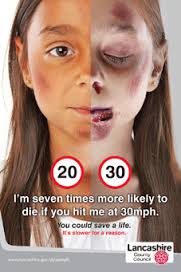
Hard Hitting Poster
Lancashire County Council in 2013 scooped a national award for a communications campaign designed to drive home the message that obeying 20mph limits in the county’s residential areas could save lives.
'Slower for a reason' was named Campaign of the Year at the Local Government Communications Reputation Awards, which are designed to recognise how effective communication with residents can help councils to deliver better services.
The poster has the message 'I'm seven times more likely to die if you hit me at 30mph.'
Back to top
Current 20mph speed limits/zones in Bedford Borough and those planned are:
Urban Bedford
Brickhill
Residential
• Carron Road area off Tyne Crescent (Implemented prior to 2008).
• Tyne Crescent and all roads on either side except Ashmead Road also for St Thomas More School (Zone implemented May 2013).
• Curlew Crescent and wider area (Implemented March 2015).
• Mallard Hill and wider area (Implemented March 2015).
• Larkway, Dove Road, Falcon Road, Fulmar Road, Pipit Rise, Merlin Gardens, The Buntings, Martin Close and Kingfisher Close (Resident's Consultation November 2016, implemented June 2018).
Schools
• Dove Road and Avon Drive (South) (when lights show) for Brickhill Primary School (Implemented July 2013).
• Hawk Drive and Falcon Avenue/Kestrel Way junction (when lights show) for Scott Primary School (Implemented July 2013).
• Waveney Avenue (south of Dart Road and north of Starling Way) (when lights show) for Brickhill and Scott Primary Schools(Implemented August 2014).
• Kimbolton Road at Avon Drive/Rowallan Drive junction (when lights show) for Brickhill Primary School (Proposal October 2018).
Castle including Town Centre Area
• Alexandra Road area – Residential (Implemented prior to 2008).
• Castle Road area – Residential (Planned 2012 but not implemented until 2022).
• High Street (St Peter's Street to St Paul's Square North) - Town Centre (Zone implemented July 2013).
• High Street from St Paul's Square north to its junction with The Embankment (Implemented April 2015).
• St Paul's Square both north and south (Implemented April 2015).
• St Mary's Street from The Embankment to Cauldwell Street (Planned 2014 but not implemented).
• Duckmill Lane from the High Street to Bedesman Lane (Implemented April 2015).
• The Embankment from the High Street to Newnham Avenue (Proposed August 2020).
• Horne Lane (Proposed March 2017).Cauldwell
• Hawkins Road, Pearcey Road and Darwin Road part - for Shackleton Primary School (Implemented January 2015).
De Parys
• Goldington Avenue area bounded by Caves Lane, Goldington Road and Kimbolton Road (Implemented March 2015).
• Brendon Avenue, Langdale and Selsey Way (Implemented March 2015).
• Caves Lane area; Caves Lane, Crediton Close, Barnstable Road, Sidmouth Close, Chalden Court, Saltash Close, Widecombe Close, Brixham Close, Honiton Way, Chudleigh Close, Dawlish Road, Seaton Drive, Hartland Avenue, Lydford Close, Salcombe Close, Chagford Close, Totnes Close, Clovelly Way and Thurlestone Close (Implemented 2020).Goldington
• Church Lane part - next to shopping area and Putnoe Primary School (Implemented 2008) and extended 70m into Needlewood Road to accommodate a new zebra crossing (Proposed December 2018).
• North of Goldington Road - Brookfield Road, Marshall Court, Cotswold Close, Parklands, Everard Road, Penlee Close, Heronscroft, Portland Close, Malvern Avenue and Purbeck Close. (Proposed Order October 2016, Order February 2017).
• Abbey Road, Ashridge Drive, Cannock close, Ettrick Drive, Greskine Close, Glenavon Road, Lymington Gardens, Strathconon Road, Manor Road, Harvey Road, Ouse Road, Mount Drive, Cornland and Barley Way (Implemented 2020).Great Denham
• Saxon Way and Anglia Way (part) (Proposed February 2022).
Harpur
• Stanley Street area – Residential.
• Warwick Avenue, Lansdowne Road, Linden Road, Dynevor Road (Implemented 2013).
• Poets area between Shakespeare Road and the railway line (Implemented April 2015).
• De Pary's Avenue, Pemberley Avenue, St Andrew's Road, St Michael's Road, St Augustine's Road, St Alban Road and St Edmund Road (Proposed Order June 2018).
• Warwick Avenue, Lansdowne Road, Linden Road, Dynevor Road (Implemented 2013).
• Poets area between Shakespeare Road and the railway line (Implemented April 2015).
• Turner Way, Kneller Close, Constable Hill, Reynolds Close, Rowlandson Way, Lely Close, Hogarth Close, Gainsborough Rise, Haden Close, Ramsey Close, Tate Close, Wedgwood Road, Cotman Close, Morland Way and Slade Walk (Proposed Order February 2021).Kempston
• The Links, The Maples, The Planes, The Rowans, The Larches and the rear of Lilac Walk (Implemented 2013).
• Area bounded by Bedford Road, Spring Road, Elstow Road and Bunyan Road (Consultation January 2014, Public Notice Proposal October 2014, Order February 2015, Implemented March 2015).
• Southfields Estate - The Elms, The Alders, Orchard Street, The Sycamores, The Hollies, Chantry Road, Chantry Avenue, Eaton Road, Highfield Road, The Briars, The Planes, The Firs, Magnolia Close, Whitebeam Close and The Silver Birches (Public Notice Proposal November 2016, Order February 2017).
• Hill rise, The Dell, Durler Avenue, The Hoo, Ditmas Avenue and Deacon Avenue (Public Notice January 2022).Kingsbrook
• Bamford Road, Barton Road, Colling Place, Dunham Close, Goodmayes Close, Harrowden Road (access road intersecting Barford Road and Lovell Road), Leith Road, Lovell Road, Reddall Close and access roads to rear of Boteler Gardens, Welbourne Gardens and Royle Gardens. (Proposal October 2018).
• Fenlake Road, Nicholls Road, Hockcliffe Road, Coombes Close, Christie Road, Gifford Road, Faldo Road, Kilpin Road, Barford Avenue, Collie Road, Mark Rutherford Road, Paradine Road, Kirkman Close, Harding Close, Acacia Road, Carter Close, Nash Road, Moulton Avenue, Cottril Way, Voyce Close, Mareth Road and Alamain Avenue.(Proposed Order February 2022).Newnham
• Wendover Drive, Risborough Road, Aylesbury Road, Hatfield Crescent and Harpenden Close (Proposal November 2020/Order January 2021).
Putnoe
• Wentworth Drive part (when lights show) outside Mark Rutherford Upper School (Implemented 2008).
• Polhill Avenue (South of Barnstable Road to Kimbolton Road) (when lights show) for St John Rigby and Castle Newnham Primary Schools (Implemented July 2013).
• Putnoe Lane (Queens Drive to south of Stancliffe Road) (when lights show) for The Hills Academy and Hazeldene Primary School (Implemented January 2014).
• Wentworth Drive part (when lights show) outside Mark Rutherford Upper School (Implemented 2008).
• Cheviot Close, Chiltern Avenue, Fairholme, Furzefield, Greenacres, Hartshill, Leasway, Mendip Crescent, Pennine Road, Pentland Road, Quantock Close, Queen's Crescent, Stancliffe Road and Woodmere (Proposed Order March 2018).
• Putnoe Heights, Hartop Close, The Graylings, Arrow Leys, Braeside,The Furlong, Uplands and Putnoe Street (between Noes 150 and 164) (Proposed Order February 2021).
• Northcote and Heathfield (Proposed Order March 2022).
Queen's Park
• All roads (Public Notice Proposal April 2014, plan updated August 2014, Public Notice Order February 2015, Implemented February 2015).
Other Areas
Bromham
• Village Road near to Bromham Primary School (when lights show) (Implemented 2014).
• Grange Lane (Public Notice Order November 2018).
• Bridge End (for 412 metre spanning over Bromham Bridge) (Public Notice Proposal December 2017).Carlton
• Bridgend (part) (Implemented November 2020).
Clapham
• The Baulk.
• Carriage Drive.
• Green Lane, Church View (Public Notice Order January 2021).Cople
• Willington Road near to Sheerhatch Primary School (ex Cople Primary School) (when lights show).
Elstow
• Abbeyfields on either side of roundabout next to Elstow Primary School (when lights show) (Implemented 2014).
Felmersham
• Carlton Road (part), Church End, Grange Road, Hunts Lane (part), Marriotts Close, Memorial Lane, Pavenham Road (part), The Old Road (part), Tithe Barn, Town Lot Lane and Trinity Close (Public Notice Proposed Order December 2016).
• The High Road (in addition to above) (Public Notice Proposed Order May 2017).Great Barford
• Silver Street Southview, Bereford Close, Goodwins Yard, Pyms Close, The Spencers, Hunts Field and Silver Street Loop (Public Notice Proposed Order February 2023).
Harrold
• Barley Kiln Lane, Brook Lane, Church Walk, Dove Lane, Priory Close, Roman Paddock, Saxon House, The Green and High Street (C26) from No 13 in a westerly direction to 13.5m east of its junction with Orchard Close (Public Notice Proposed Order November 2015).
• Eagle Way, Mansion Lane, Orchard Lane, Dickens Close, Wood Road (part) and High Street (Public Notice Proposed Order November 2016, Public Notice Order January 2017).Keysoe
• Kimbolton Road on either side of Keysoe Row E & W for for Kymbrook Primary School (when lights show)
Lower Dean
• High Street from unnamed road (C4) to 18m west of 'Walnut Cottage' High Street (Public Notice Proposed Order May 2015, Order June 2015).
• High Street existing limit extended for 55 metres in a north westerly direction (Public Notice Proposed Order November 2015).Marston Moretaine
• Woburn Road near Church End Primary School (when lights show) (Implemented 2014).
New Cardington
• The whole of the area west and east of the new A600 (Implemented 2012).
Pertenhall
• Wood End Lane, Chadwell End and Green End (Public Notice Draft Order March 2023).
Radwell
• Moor End Road from Felmersham Road to Moor End Lane (Implementated June 2014).
Renhold
• The Spires Estate off Norse Road, Bedford; Maskell Drive Bedford, Langlands Road Bedford, Silverburn Close Renhold, Parish Close Renhold, Lammerside Renhold, Pedley Way Renhold and Kenwyn Close Renhold (Implemented 2020).
Riseley
• Gold Street, Church Lane and Kings Close (Implemented 2013).
Saploe
• Saploe Lane (Implemented 2020).
Sharnbrook
• High Street, Church Lane and Park Lane (Implemented 2013).
Shortstown
• The whole of the area west of the old A600 and the area between the old and new A600 (Implemented 2012).
Stevington
• Church Road, Park Road (from Court Lane to Farley Way), Silver Street (from Church Road/Park Road/Court Lane to the westernmost boundary of 57 Silver Street) and Court Lane (from Park Road to the westernmost boundary of 19 Court Lane) (Public Notice January 2022).
Stewartby
• Park Crescent next to Broadmead Primary School (when lights show) (Implemented 2014).
• The Crescent for Marston Vale Middle School (when lights show) (Implemented 2014).
• The Crescent and Wavell Close (between Stewart Way and The Crescent) (Proposed Order March 2018).Thurleigh
• High Street (extending in an easterly direction from its junction with Church End to its junction with The Close) and Vicarage Green (Public Notice Proposed Order February 2023).
Upper Dean
• Shay Lane, Brook Lane and Shelton Road from Brook Lane/Shay Lane junction for 73m in north west direction (Public Notice Proposed Order May 2015, Order June 2015).
• High Street for 201 metres outside Eileen Wade Primary School (Public Notice Proposed Order November 2015).Wilden
• High Street next to Wilden Primary School (when lights show) (Implemented 2014).
Wixams
• Brooklands Avenue and surrounding roads; Bittern Lane, Bluewater Quay Knoll Gardens, Kingfisher Road Green Lane, Moorland Close Teal Close, Greenside Close Dove Lane, Fieldfare View Ladybird Way, Partridge Place Eagle Mews, Brambling Gardens Harrier Leys, Little Causeway Avocet Road, Millbrook Close Nightingale Court, Lakeside Way Thistle Lane, Mallard Court Lesser Avenue, Peacock Gardens Hummingbird Way, Little Owl Lane Dane Lane, Bluebird Gardens Bedford Road, Wren Terrace Wagtail Gardens, Piper Lane The Rosary, Parkview Terrace Kestrel Gardens, Woodpecker Gardens Pheasant Grove and School. Lane(Public Notice Proposed Order February 2023).
Wootton
• Bedford Road near Wootton Primary School (when lights show) (Implemented 2014).
A map of where 20mph speed limits/zones are in the Bedford/Kempston urban area can be seen here.
Back to top
20mph zone versus 20mph speed limit
A 20mph zone is usually a short section such as outside a school with the speed enforced by traffic calming.
A 20mph speed limit normally covers a number of roads or even a whole town or city and the speed is enforced only with signs and very little traffic calming.
Back to top
For further extensive information on 20mph speed limits visit 20's Plenty for US and for their September 2015 report on the subject Brake - the road safety charity and their key Fact webpage.
A road safety factsheet on 20mph zones and speed limits was published in 2017 by ROSPA - The Royal Society for the Prevention of Accidents and a 'Guide to 20mph Limits' in December 2019.
Back to Campaigning
Back to top